Difference between revisions of "GENIE Gridspec Diagrams UnstructuredCell"
Genie-user (talk | contribs) |
Genie-user (talk | contribs) m |
||
| (2 intermediate revisions by the same user not shown) | |||
| Line 1: | Line 1: | ||
| − | Unstructured cells provide detailed structural information about cells. Unstructured cells are particularly useful for high-resolution grid [[ | + | Unstructured cells provide detailed structural information about cells. Unstructured cells are particularly useful for high-resolution grid [[GENIE_Gridspec_Diagrams_Tile|tiles]] that must cover detailed topography -- for instance numerically generated "unstructured triangular" [[GENIE_Gridspec_Diagrams_Discretisation|discretisations]]. Vertices are specified using an appropriate point type; currently only a geo-referenced type is available consisting of geographic longitude and latitude coordinates. |
''Since vertices are likely to be shared between cells, it may be more appropriate to associate vertices with a tile instead of a cell, and reference the vertices from cells instead (a similar thing is done for edges). This will avoid storing duplicate vertex data.'' | ''Since vertices are likely to be shared between cells, it may be more appropriate to associate vertices with a tile instead of a cell, and reference the vertices from cells instead (a similar thing is done for edges). This will avoid storing duplicate vertex data.'' | ||
| Line 5: | Line 5: | ||
[[Image:unstructuredcell_type.png|center]] | [[Image:unstructuredcell_type.png|center]] | ||
| − | ''Note: the [[ | + | ''Note: the [[GENIE_Gridspec|gridspec overview]] contains introductory and background information on the gridspec; more detailed information can be found in Balaji's gridspec document on the [http://www.earthsystemcurator.org/index.php?option=com_content&task=view&id=38&Itemid=74 Earth System Curator] website.'' |
Latest revision as of 17:53, 26 February 2007
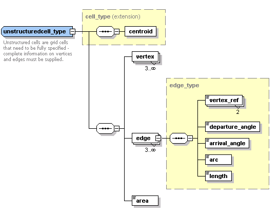
Unstructured cells provide detailed structural information about cells. Unstructured cells are particularly useful for high-resolution grid tiles that must cover detailed topography -- for instance numerically generated "unstructured triangular" discretisations. Vertices are specified using an appropriate point type; currently only a geo-referenced type is available consisting of geographic longitude and latitude coordinates.
Since vertices are likely to be shared between cells, it may be more appropriate to associate vertices with a tile instead of a cell, and reference the vertices from cells instead (a similar thing is done for edges). This will avoid storing duplicate vertex data.
Note: the gridspec overview contains introductory and background information on the gridspec; more detailed information can be found in Balaji's gridspec document on the Earth System Curator website.
